Visit www.usda.gov/drought for the latest information regarding USDA’s Drought Disaster response and assistance.
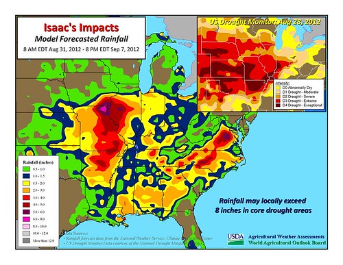
Hurricane Isaac has grabbed most of the weather headlines in recent days, but drought remains deeply entrenched across nearly two-thirds of the continental United States. According to the latest U.S. Drought Monitor, dated August 28, drought covered 62.9% of the Lower 48 states, down only slightly from a peak of 63.9% on July 24. However, during the five-week period from July 24 to August 28, the portion of the country in exceptional drought (D4) increased from 2.4 to 6.0%.
In fact, hot weather in recent days across the central and northern Great Plains has caused further deterioration in pasture conditions. According to USDA’s National Agricultural Statistics Service, at least half of the rangeland and pastures were rated in very poor to poor condition on August 26 in every Great Plains state (from Texas to Montana and North Dakota). Overall, twenty states – from California to Ohio – are reporting at least 50% of their rangeland and pastures in very poor to poor condition. The list is topped by Missouri (99% very poor to poor), Nebraska (95%), Kansas (92%), and Illinois (90%).

The good news for Missouri and Illinois is that heavy rainfall associated with Isaac’s remnant circulation is spreading across the southern Corn Belt. By mid-day Friday, August 31, Tropical Depression Isaac was centered over northwestern Arkansas, drifting northward. Maximum sustained winds have diminished to 25 mph. During the Labor Day weekend, Isaac’s remnants will turn eastward across the middle Mississippi Valley and the lower Midwest. Additional rainfall could reach 2 to 6 inches or more from the Mid-South into the eastern Corn Belt, where positive impacts of Isaac’s rainfall will include pasture recovery and replenishment of soil moisture in preparation for the soft red winter wheat planting season.
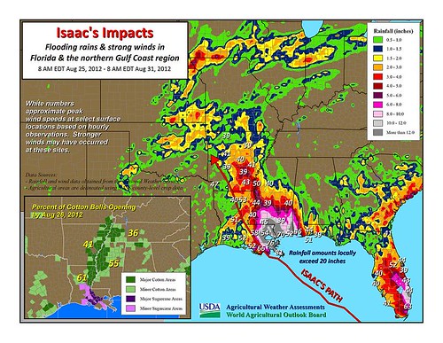
As Isaac continues to decay over land, flooding will remain the primary threat. Indeed, significant lowland flooding persists in the central Gulf Coast region, including southeastern Louisiana and southern Mississippi, where as much as 10 to 20 inches of rain fell. Although steady rainfall has ended in the areas hardest-hit by flooding, locally heavy showers persist. According to information provided by the National Weather Service and the U.S. Geological Survey, record-high water levels were established in a few river basins, including East Hobolochitto Creek near Caesar, Mississippi. Elsewhere in Mississippi, the Bogue Chitto River near Tylertown climbed nearly 15 feet above flood stage on August 31 – the highest water level in that location since February 2003. Similarly, the Tangipahoa River near Kentwood, Louisiana, crested almost four feet above flood stage on August 31, less than eight inches below the high-water mark of 4.5 feet above flood stage established on January 25, 1990.
In Isaac’s wake, agricultural impact assessments are getting underway across the central Gulf Coast region, which was most heavily affected by Isaac’s rain, wind, and coastal storm surge. Updated information will be available next week, when USDA/NASS will release updated crop progress and condition statistics on Tuesday, September 4 at 4:00 pm EDT. Crops to watch include cotton and rice. In the lower Mississippi Valley, some of the cotton crop was hit by torrential rainfall and tropical storm-force wind gusts (39 mph or greater). Before Isaac hit, Delta cotton in the vulnerable open-boll stage of development ranged from 32% open on August 26 in Missouri to 61% in Louisiana. Meanwhile, the Delta rice harvest had begun in the days before Isaac hit. By August 26, the rice harvest ranged from 6% complete in Missouri to 71% finished in Louisiana. Rice still in the field may have been susceptible to being lodged, or knocked down, by rain and wind.
