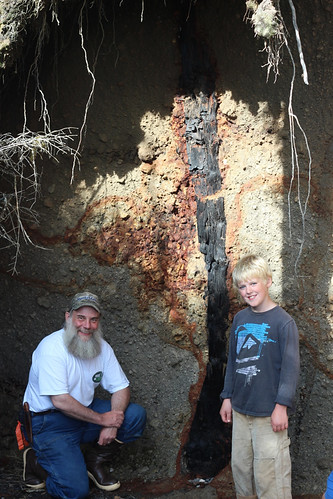
Seldom does one find a way to directly date a prehistoric volcanic eruption, but 11-year-old Blake LaPerriere opened such a door for excited scientists in Southeast Alaska.
Last September, Blake, his parents, and his younger brothers were exploring a beach on southwestern Kruzof Island, part of the Tongass National Forest landscape and just west of Sitka, Alaska, where they live. Blake investigated a deeply incised creek behind a pile of beach drift where he found a standing burnt tree embedded in a tall bank of pumice. He brought it to his family’s attention, asking “Do you think that’s from a volcanic eruption a long time ago?”
Curious, Blake’s father Zach took photos and sent them my way.
As the forest’s geologist, it didn’t take me long to respond. Thanks to good weather, I was able to travel by boat to meet the family at the site the next weekend. Accompanied by Kitty LaBounty, assistant professor of natural sciences at University of Alaska Southeast, Deidra LaBounty, a geology student volunteer, and Jay Kinsman, a Forest Service geologist, we examined the site.
We carefully documented what we found, sending samples of the wood from the embedded tree to a lab for radiocarbon dating and to the University of Oregon for identification. First, we learned that the tree was indeed ancient – dating back 13,180 years. Then, Jamie Dexter from the University of Oregon confirmed the tree as Picea sitchensis, or Sitka spruce, making this one of the oldest records of Sitka spruce in Southeastern Alaska.
After I gave Blake the news on the age and identification of his find, I explained how the tree came to be there.
Southern Kruzof Island consists of more than a dozen volcanic vents and domes referred to as the Mount Edgecumbe Volcanic Field. Mount Edgecumbe dominates the landscape rising to more than 3,200 feet. Its symmetric cone and crater create a striking image. The field first erupted approximately 600,000 years ago, with volcanic activity continuing until 5,000 to 6,000 years ago.

About 13,180 years ago, a violent eruption on Crater Ridge just north of Mount Edgecumbe resulted in deep deposits of rhyolitic airfall, what we know as pumice and ash, and pyroclastic flows or fluidized rock fragments and hot gases. These fast moving flows swept down from the saddle between Crater Ridge and Mount Edgecumbe, rapidly burying the forest and vegetation on the lower slopes.
Blake had discovered one of these trees.
Knowing the tree’s age helps scientists establish the age of the simultaneous eruptions which spread ash across much of Southeast Alaska.
Interestingly, at the time of the eruption that encased the Kruzof tree, global sea levels were about 174 feet lower than today. The lands west of Sitka were a coastal plane with fresh water lakes.
The Kruzof tree is a record of an established forest in what was likely a refugium – a place where plants and animals persisted during the last ice age. This preserved relic gives us a small snapshot into the timing and extent of glaciation, the prehistoric climate, and the possibility of refugia where other plant and animals persisted and early migrants to North America may have passed. About 250 years after the eruption that trapped the tree, rising sea levels inundated the coastal plane and fresh water lakes creating Sitka Sound.
My plan is to return to the area in the future to see if other trees emerge as waves erode the bank. I’ll be looking for evidence of the soil and vegetation, which must be buried beneath the pumice flow.
Read more on the area’s geologic history and the Alaska Volcano Observatory at these links.

